Date of formation: Kandamal District was created from Boudh-Kandhamal District on 1st April 1993.
Area: 8021 square kilometers
Density of population: 91 people per square kilometer
Literacy Rate: 65.12 % - Male: 78.41 %, Female: 52.46 %
Male Female Ratio: 1000:1037
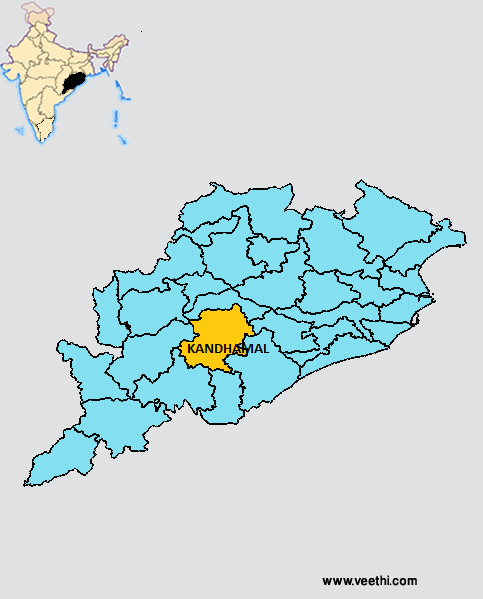
Boundaries of Kandhamal District
North: Boudh District, Orissa
South: Rayagada District and Gajapati District, Orissa
East: Nayagarh District, Orissa
South East: Ganjam District, Orissa
West: Kalahandi District, Orissa
Kandhamal District Average Rainfall: 1754.7 mm
Kandhamal District Maximum Temperature in Summer: 42.6 deg C
Kandhamal District Minimum Temperature in Winter: 1.3 deg C
KANDHAMAL DISTRICT MAP
Sub Divisions: Phulabani, Baliguda
Tehsils: Baliguda, G. Udayagiri, Kandhamal, Daringbadi
Blocks: Phulabani Sadar, Baliguda Sadar, Raikia, Tikabali, Kotagarh, Chakapada, Nuagan , G. Udayagiri, Tumudibandha, Khajuripada, Phiringia, Daringibadi
Assembly Constituencies: Baliguda, G. Udayagiri, Phulabani
Kandhamal District Nearby Attractions
1. Balaskumpa
2. Belghar
3. Chakapada
4. Daringibadi
5. Putudi
6. Jalespata
7. Dungi
8. Kalinga Valley
9. Ludu
10. Mandasaru Kuti
11. Pakadajhar
12. Rushimal
13. Urmagada
Kandhamal District Facts: Daringi Badi in this district is known as Kashmir of Orissa and is a good summer resort.
Major Agricultural Products: Rice, maize, arhar, blackgram, niger, mango, citrus, banana, tomato, cauliflower, cabbage
Festivals: Danda Nach, Sisaa Laka, Maranga Laka, Bora Laka
What is Kandhamal District Famous For: Elephants, handicrafts and terracotta works
Last Updated : Sunday Jun 10 , 2012


