Date of formation: Nuapada District was carved out of Kalahandi District on 27th March 1993.
Area: 3852 square kilometers
Density of population: 157 people per square kilometer
Literacy Rate: 58.20 % - Male: 71.55 %, Female: 45.21 %
Male Female Ratio: 1000:1020
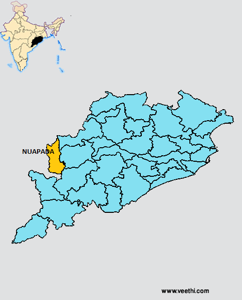
Boundaries of Nuapada District
North and West: Chhattisgarh
South: Kalahandi District, Orissa
East: Balangir District and Bargarh District, Orissa
Nuapada District Average Rainfall: 764 mm
Nuapada District Average Temperature in Summer: 31.91 deg C
Nuapada District Average Temperature in Winter: 19.41 deg C
NUAPADA DISTRICT MAP
Major Rivers: Udayanti River, Sundar River
Sub Divisions: Nuapada
Tehsils: Nuapada
Blocks: Nuapada Sadar, Sinapali, Komana, Jonk, Boron
Assembly Constituencies: Nuapada, Khariar
Nuapada District Nearby Attractions
1. Budhikomna
2. Patalaganga
3. Patora
4. Sindursil
5. Thipakhol
6. Yogimatha
7. Jogeswar Temple
8. Upper Jonk Irrigational Project
9. Maraguda Valley
10. Sunabeda Wild Life Sanctuary
Nuapada District Facts: It is one of the 19 most backward regions of Orissa that is receiving funds from the Backward Regions Grant Fund Program.
Major Agricultural Products: Paddy, mustard, sunflower, mango, groundnut, grams
Mineral Resources: Laterite, graphite, bauxite, lime stone, gem stone
Forest Resources: Kendu leaf, bamboo, broom grass, mohua flower and seed, antia bark, sabai grass, timber, bija, asan, bandhan, teak
Last Updated : Sunday Jun 10 , 2012


