Date of Formation: 1998
Area: 9046 square kilometers
Density of Population: 59 people per square kilometer
Literacy Rate: 42.67 % - Male: 52.69 %, Female: 32.88 %
Male Female Ratio: 1000:1022
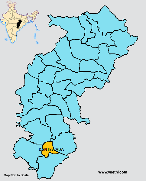
Boundaries of Dantewada District
North: Narayanpur District, Chhattisgarh
South: Sukma District, Chhattisgarh
East: Kondagoan District, Chhattisgarh
West: Bijapur District, Chhattisgarh
Dantewada District Average Rainfall: 1237.5 mm
Dantewada District Average Temperature in Summer: 33.97 deg C
Dantewada District Average Temperature in Winter: 22.23 deg C
DANTEWADA DISTRICT MAP
Major Rivers: Indravati, Godavari, Shabhari, Shankhini, Dankiny
Blocks: Dantewada, Geedam, Katekalyan, Kuwakonda
Assembly Constituencies: Dantewada
Dantewada District Nearby Attractions
1. Dantewada
2. Bailadila
3. Barsur
4. Bodhghat Sath Dhar
5. Memory Pillar of Gamawada
6. Pamed Sanctuary
Dantewada District Facts: This is the third least populous district of Chhattisgarh next only to Narayanpur District and Bijapur District as of 2011.
Major Agricultural Products: Paddy, maize, kudo-kutki
Major Occupations: Farming, animal husbandry, poultry farming, fishery, basket making
Folk Arts: Leja, Reelo, Mariro, Sona, Dhakul Geet, Chait Parab Geet, Kotni, Jhaliyana Geet, Dandami Maria, Gurgal, Karsad, Dandari, Gedi, Giti, Bhatra, Dandari
Spoken Dialects: Halbi, Bhatri, Gondi, Parji, Dharvi, Dorli, Aboojhmarhi, Damdami
Fairs and Festivals: Vijja Pandum, Ama, Pane, Dela, Podla, Amus, Chikma, Karta, Pane Pandum, Gadi Pandum
What is Dantewada District Famous For: Moaist Activities and Murga Ladai or Cock Fight
People of Dantewada District: Tribals namely Muriyas, Dandami Mariyas, Gonds, Dola, Halba
Last Updated : Thursday Jun 14 , 2012


