Date of Formation: 22nd February 1972
Area: 3819 square kilometers
Density of Population: 103 people per square kilometer
Literacy Rate: 63.26 % - Male: 59.75 %, Female: 66.71 %
Male Female Ratio: 1000:1008
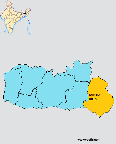
Boundaries of Jaintia Hills District
North and East: Assam
South: Bangladesh
West: East Khasi Hills District, Meghalaya
Jaintia Hills District Average Rainfall: 4370.9 mm
Jaintia Hills District Average Temperature in Summer: 27.19 deg C
Jaintia Hills District Average Temperature in Winter: 17.41 deg C
JAINTIA HILLS DISTRICT MAP
Major Rivers: Umngot, Myntdu, Lukha, Myntang
Blocks: Amlarem, Khliehriat, Laskein, Saipung, Thadlaskein
Assembly Constituencies: War Jaintia, Raliang, Nartiang, Nongbah, Wahiajer, Jowai, Rymbai, Sutnga Shangpung
Jaintia Hills District Nearby Attractions
1. Thadlaskein Lake
2. Lale Falls
3. Summer Palace
4. Syntu Ksiar
5. Stone Bridge
6. Borghat Temple
7. Lubha Bridge
8. Syndai Caves
9. Kiang Nangbah Monument
10. Letein Valley
11. Umhang
12. Dawki Bridge
13. Waikhyrwi
14. Nartiang Temple
15. Lechka
16. Sutiang Fort
17. Nartiang Monoliths
18. Memjubel
19. Lalong
20. Rupasor Bathing Ghat
21. Lawmusiang
22. Shrine of Our Lady of Good Health
Jaintia Hills District Facts: Marangksih Peak is the highest peak in the district. Coal deposits are found in Bapung, Lakadong, Chyrmang, Musiang Lamare, Sutnga, Iooksi, Rymbai, Byrwai and Jarain and limestone deposits are found in Lumshnong, Nongkhlieh, Sutnga, Lakadong, Syndai and Nongtalang.
Major Industrial Products: Basket, trays, mats, sunshades, containers, knives
Natural Resources: Granites, phyllite, genesis, sandstone, limestone
What is Jaintia Hills District Famous For: Boating
Famous People From Jaintia Hills District: Vincent Pala
Jaintia Hills District Pin Codes
Last Updated : Thursday Jun 14 , 2012


