Uttarakhand is an Indian state located in the northern part of India. The capital of Uttarakhand is Dehradun. The state was carved out of Uttar Pradesh on 9th November 2000 and it was formerly known as Uttaranchal. Uttarakhand means northern part of the country. The name Uttaranchal was officially changed in January 2007. Uttarakhand is popular for the Chipko environmental movement.
History of Uttarakhand
The region of Uttarakhand was mentioned in the old scriptures as Kedarkhand and Manaskhand. From 13th to 18th century, Kumaon kingdom ruled in its eastern part and Garhwal Kingdom ruled in its western parts. In 1791, Kumaon kingdom was captured by the Gurkha Empire of Nepal and in 1803 Garhwal Kingdom also was defeated by Gurkhas. The Anglo-Nepalese War in 1816 and the resulting Treaty of Sugauli made these areas come under British domination.
After the independence of India, the kingdom of Garhwal was added to the Uttar Pradesh state and this was referred as Uttarakhand. The agitations to get a separate state led to the passing of the Uttar Pradesh Reorganization Bill on 24th September 1998 in the legislative assembly and as per the Uttar Pradesh Reorganization Act 2000, the new state of Uttaranchal was created on 9th November 2000. And in October 2006, the state was renamed Uttarakhand.
Geography of Uttarakhand
Uttarakhand spreads over an area of 53,566 square kilometers and among that 93% are mountainous. The state has Nepal in the east, Tibet Autonomous Region in the north, Uttar Pradesh in the south and Himachal Pradesh in the northwest. 63% of the total area is covered by forests. The northern parts of Uttarakhand are covered by the Himalayas and are filled with snow and glaciers. Various types of forests such as temperate coniferous forests, western Himalayan subalpine conifer forests, temperate western Himalayan broadleaf forests, Himalayan subtropical pine forests, Upper Gangetic Plain moist deciduous forests and Terai Duar savanna and grasslands are found here. As different parts of Uttarakhand lie in different altitudes, the climates also vary greatly.
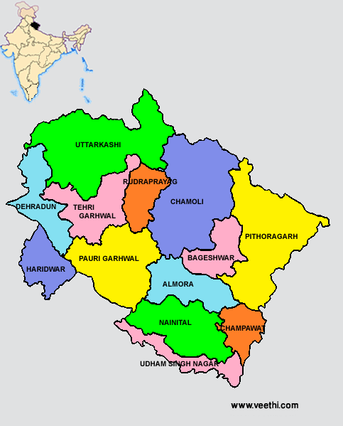
Uttarakhand State Map With Districts
There are 13 districts in Uttarakhand as of June 2012 and these were grouped under two major divisions namely Kumaon and Garhwal. Given below is the Uttar Pradesh state map with all 13 districts marked.
List of Districts of Uttarakhand
|
Kumaon Division |
Garhwal Division |
|
|
Apart from these districts, on 15th August 2011, the Chief Minister of Uttarakhand proposed the creation of four more districts namely Didihat, Ranikhet, Kotdwar and Yamunotri.
People and Culture of Uttarakhand
The population of Uttarakhand as of 2011 census is 10,166,752 with a density of 190 people per square kilometer. Hindi and Sanskrit are the official languages of the state. The people of Uttarakhand are called Kumaoni and Garhwali according to their place of origin. The dialects of Pahari language are spoken here and some of them are Kumaoni, Garhwali, Jaunsari and Bhotiya. 85% of the people are Hindus, 10.5% are Muslims, 2.5% are Sikhs and Christians, Buddhists and Jains constitute the remaining 0.5%. The state has the highest percentage of Brahmin population in India.
Education in Uttarakhand
There are many popular educational institutions in Uttarakhand namely Govind Ballabh Pant University of Agriculture and Technology, Indian Military Academy, Forest Research Institute, Govind Ballabh Pant Engineering College, Bipin Chandra Tripathi Kumaon Engineering College, Kumaun University, etc.
Some of the important schools in Uttarakhand are G D Birla Memorial School, Welham Girls School, Welham Boys School, Summer Valley School, Brightlands, St. Joseph’s Academy, Woodstock School, Birla Vidya Mandir, Sherwood College, St. Mary’s Convent at Nainital, etc.
Economy of Uttarakhand

The GSDP of the state in 2011 was 775.8 billion rupees. When the state was carved out of Uttar Pradesh, 12% of the total output went with it. The state had enacted new industrial policy in 2003 and this has initiated many new investments. There are seven industrial establishments in Uttarakhand set up by the State Industrial Development Corporation of Uttarkhand to improve and promote investments.
The GSDP in 1999-2000 was 132758 million rupees and this increased to 5999154 million rupees in 2009-10. The major contributors of the economy of Uttarakhand are agriculture, forestry, fishing and mining. More than 70% of people are involved in agriculture and related activities. The service sectors like banking, real estate, transport and public administration contribute to nearly half of the GSDP.
Uttarakhand Transportation and Tourism
Uttarakhand is connected with other parts of country by roads, rails and air networks. The airports in Uttarakhand are Jolly Grant Airport at Dehradun, Pantnagar Airport, Naini-Saini Airport at Pithoragarh, Airport at Uttarkashi, Gochar and Agustmuni.
There are many places of tourist attraction in Uttarakhand that include national parks, sanctuaries, hill stations and pilgrimage centers. The Nanda Devi National Park and Valley of Flowers are the UNESCO World Heritage Site. Some of the tourist destinations in Uttarakhand are as follows.
Yamunotri
Hemkund Sahib
Some of the national parks in Uttarakhand are
Jim Corbett National Park at Ramnagar in Nainital District
Valley of Flowers National Park in Chamoli District
Nanda Devi National Park in Chamoli District
Rajaji National Park in Haridwar District
Govind Pashu Vihar National Park in Uttarkashi District
Gangotri National Park in Uttarkashi District


.jpeg "Neha Saxena (film Actress)")
