Tripura is one of the seven Indian states located in the North Eastern part of India. Mizoram, Assam and Bangladesh border Tripura. The capital of Tripura is Agartala. Only one road NH 44 connects this state with other parts of India. Tripura became a part of the Indian union from 15th October 1949. The population of Tripura is indulged in shifting cultivation and the main crop is rice. Major portion of the state is covered by marshy land and cane-brakes making it unfit for cultivation.
History of Tripura
Tripura was initially a princely state and was ruled by the tribal kings and the kings of the Manikya dynasty from the year 1432. The integration of the state with India was initiated by the Ganamukti Parishad movement. From 1st November 1956, it became a union territory. The ministry of Tripura was formed on 1st July 1963 and it attained the full fledged statehood on 21st January 1972. During the partition of India, many people came from East Pakistan into this state as refugees leading to major economic setback.
Tripura Sundari is the important deity of the land and so the common belief is that the land got its name from Tripura Sundari. It is also said that the place was originally known as Tuipra meaning the land near water. Some people say that there is the temple of Tripureshwari at Udaipur and the name was derived from it.
Geography and Climate of Tripura
Tripura spreads over an area of 10,491 square kilometers and is the third smallest state in India. The state comprises of hill ranges like Boromura, Atharamura, Shakhan, Jampui and Longtharai, valleys such as Khowai, Dhalai, Manu and Deo and plains. The highest point of the state is Betling Shib located in the Jampui hills at an altitude of 939 meters above the mean sea level. The rivers Khowai, Dhalai, River Manu, Juri, Langai, Gomoti, Muhuri and Feni are the rivers that flow through this region making it fertile.

The climate of the state could be categorized into four main seasons, winter season from December to February, Summer season in March and April, Monsoon season from May to September and Post Monsoon season from in October and November. During the monsoon season, the southwest monsoon brings heavy rainfall. The highest rainfall is received from June to August and the average rainfall of the state is 2500 mm per annum.
Natural Resources of Tripura
Tripura lies in the Indomalaya ecozone and 57.3% of the land of the state is covered by forests. It has evergreen forests, deciduous forests, grasslands and swamp and has species of plants like Dipterocarpus, Syzygium, Eugenia, Amoora, Albizia, Lagerstroemia, Macaran ga, sugarcane, etc.
There are more than 90 species of land mammal living here that include elephant, bear, binturong, wild dog, porcupine, barking deer, wild boar, sambar deer, gaur, leopard and more than 300 species of birds. There are many wildlife sanctuaries in the state namely Gumti Wildlife Sanctuary, Rowa Wildlife Sanctuary, Trishna Wildlife Sanctuary, Sipahijola Wildlife Sancutary, Clouded Leopard National Park and Rajbari National Park.
Tripura State Map With Districts
Initially there were only four districts in Tripura. On 21st January 2012, the state was divided into 8 districts and 23 subdivisions. Given below is the Tripura state map with all 8 districts marked.
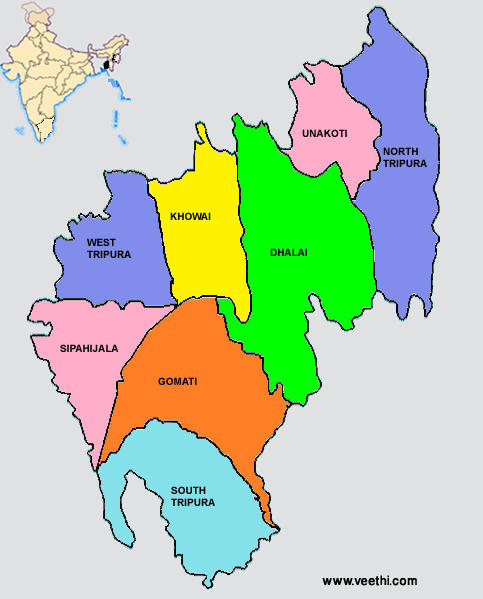
List of Districts and their headquarters in Tripura
|
Districts |
Headquarters |
Districts |
Headquarters |
|
Sipahijala |
Bishramganj |
Khowai |
|
|
Gomati |
Udaipur |
Unakoti |
Kailashahar |
|
Ambassa |
Belonia |
||
|
Dharmanagar |
Agartala |
People and Culture of Tripura
According to the 2011 census, the population of the place is 36, 71, 032. The important languages spoken here are Bengali and Kokborok. This is the most populous states among the seven North Eastern Indian states. 85.6% of the population are Hindus, 8% are Muslims, 3.2% are Christians and 3.1% are Buddhists.
The different communities in Tripura are Bengali, Tripuri, Manipuri, Chakma, Kuki, Mizo, Magh and Bishnupriya Manipuri. As a result of this people of various cultures live here and the state has a rich cultural heritage. The musical instruments like sarinda, sumui and chongpreng are their indigenous instruments. Hozari dance, Bizhu dance and Dhamail dance are performed during festivals like Goria Puja and Bizhu festival.
Education and Sports of Tripura
The literacy rate of the state is 87.75%. Both the state government and the private institutions run the schools and the medium of instruction is Bengali or English. Some of the important centers of higher education are Holy Cross College, MBB College, Tripura Institute of Technology, Agartala Government Medical College, National Institute of Technology, Tripura Medical College, Tripura University and Tripura Institute of Paramedical Science. The popular sports of the region are football and cricket. In the Ranji Trophy it participates in the eastern state team.
Economy of Tripura
Agriculture is the main occupation of the people of Tripura which contributes to 64% of the total employment. It also accounts to 485 of the State Domestic Product. Due to the geographic features only 27% of the land is available for cultivation. The major crop is rice, sugarcane, jute and pulses and the other plantation crops grown here are pineapple, oranges, cahewnut, jackfruit, rubber and tea.
The tourism and handicrafts industries are other major sources of income of the people. The bamboo and cane handicrafts of Tripura like baskets, chairs, mats and handbags are very famous in all parts of India. High quality timber is available from the forests of the state.
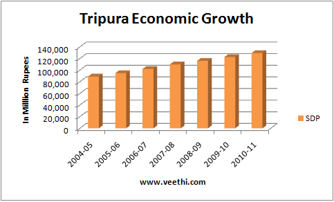
Though there are only very small amount of mineral deposits in the state it has good amount of natural gas. The per capital income of the people per year is 33, 493 INR. The Gross State Domestic Product increased from 8, 904 crore rupees in 2004 – 05 to 12, 947 crore rupees in 12, 947 in 2010 – 11.
Tripura Transportation
There is an airport in Agartala, the capital of Tripura and it is connected by air from Kolkata, Silchar and Guwahati and also to the Indira Gandhi Airport in Delhi. The NH 44 connects Tripura with the other parts of the country through Assam. Express trains runs between Agartala and Lumding daily. The train also connects Agartala to Silchar and Lumding in Assam and Dharmangar in Tripura.
The buses are the main modes of transport within the state. Auto rickshaw and cabs are also available. A helicopter service connects Agartala with the other northern parts of the state.
Tripura Tourism
Tourism is one of the fastest growing industries in Tripura. There are many places of interest in this state that contribute to the economic development of the state.
List of nearby attractions in Tripura
|
Nearby Attractions |
Area |
Distance from Agartala |
|
Ujjanta Palace |
Agartala |
Located in main city |
|
Neermahal Palace |
Melagarh |
50 km |
|
Maata Bari Temple |
Udaipur |
60 km |
|
Bhubaneswari Temple |
Udaipur |
60 km |
|
Unakoti |
Kailasahar |
150 km |
|
Rose Valley Park |
Agartala |
In outskirts of the city |
|
Akhaura Border |
Agartala |
Located in main city |
|
Temple of 14 Gods |
Old Agartala |
15 km |
|
Malanchya Nivas |
Agartala |
Located in main city |
|
Kamalasagar |
Kashba |
40 km |
|
Pilak |
South Tripura |
100 km |
|
Jampui Hills |
North Tripura |
200 km |