Date of Formation: 14th November 1969
Area: 3271 square kilometers
Density of population: 109 people per square kilometer
Literacy Rate: 75.00 % - Male: 80.85 %, Female: 68.80 %
Male Female Ratio: 1000:939
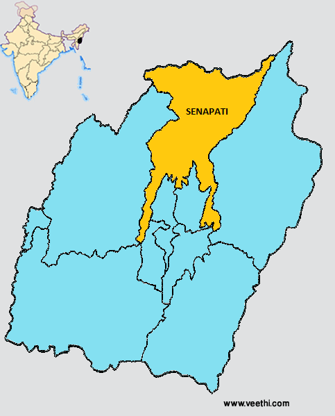
Boundaries of Senapati District
North: Phek District, Nagaland
South: Imphal East District and Imphal West District, Manipur
East: Ukhrul District, Manipur
West: Tamenglong District, Manipur
Senapati District Average Rainfall: 2316.6 mm
Senapati District Average Temperature in Summer: 23.80 deg C
Senapati District Average Temperature in Winter: 14.28 deg C
SENAPATI DISTRICT MAP
Major Rivers: Barak, Iril, Ithoi, Irang, Imphal, Lane
Sub Divisions: Tadubi, Paomata, Purul, Kangpokpi, Saikul, Gorkha Tapon
Development Blocks: Tadubi, Paomata, Saikul, Kangpokpi
Circles: Island, Kangchup, Willong, Phaibung
Assembly Constituencies: Tadubi, Mao, Karong, Kangpokpi, Saikul, Saitu
Senapati District Nearby Attractions
1. Senapati
2. Maram Khullen
3. Yangkhullen
4. Mao
5. Liyai
6. Makhel
7. Dzuko Valley
8. Purul
Senapati District Facts: This district was formerly known as Manipur North District and had its headquarters at Karong. On 13th December 1976, Senapati was made its headquarters and the district was renamed Senapati District on 15th July 1983.
Major Agricultural Products: Paddy, maize, cabbage, potato, cereals
Major Industrial Products: Bed sheets, phaneks, mosquito nets, bamboo baskets, fishing nets, furniture, carpentry works, pottery, mats
Educational Institutions: Damdei Chrostian College, Hill College, Kangpok Mission College
Festivals: Thounii, Laonii, Chiithuni, Saleni, Ponghi, Kanghi
What is Senapati District Famous For: Naked Wrestling Festival
Last Updated : Sunday Jun 10 , 2012


