Date of Formation: Narmada District was carved out of Vadodara District and Bharuch District on 2nd October 1997.
Area: 2755 square kilometers
Density of Population: 214 people per square kilometer
Literacy Rate: 73.29 % - Male: 82.60 %, Female: 63.62 %
Male Female Ratio: 1000:960
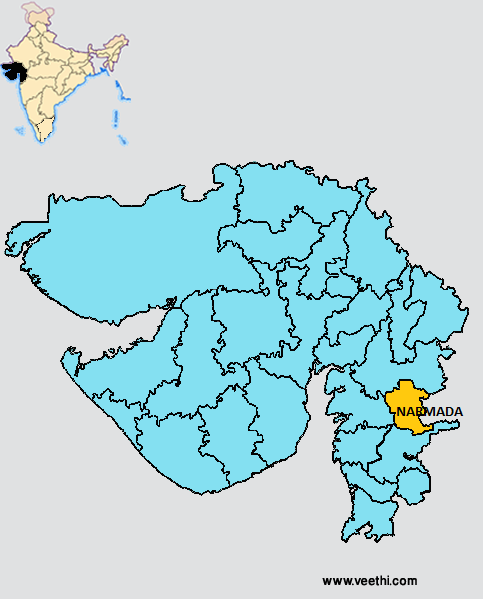
Boundaries of Narmada District
North: Vadodara District, Gujarat
South: Tapi District, Gujarat
East: Maharashtra
West: Baruch District, Gujarat
Narmada District Average Rainfall: 1257.9 mm
Narmada District Average Temperature in Summer: 31.76 deg C
Narmada District Average Temperature in Winter: 22.37 deg C
NARMADA DISTRICT MAP
Major Rivers: Narmada, Karjan, Main, Ashwini, Tarap
Blocks: Dediapada, Narmada, Sagbara, Tilakwada
Assembly Constituencies: Nandod, Dediapada
Narmada District Nearby Attractions
1. Sardar Sarovar Surpaneshwar Temple Gora
2. Vijayraj Palace
3. Shoolpaneshwar Sanctuary
4. Malsamot Waterfall
Narmada District Facts: It is one of the six most backward districts in Gujarat receiving funds from Backward Regions Grant Fund Program. This is the third least populous district in Gujarat next only to Dang District and Porbundar District.
Major Agricultural Products: Jowar, maize, sugarcane, tuwar, cotton, cane, grams, plantain, sesame, bajra
Major Industrial Products: Textiles, sugar, chemicals, agro industries
Major Educational Institutions: Government Arts College, Shri Ratnasinhji Mahida Commerce College, Shri Maharaja Rajendrasinhji Arts Science College, Faculty of Technology DDU, M.D. Kahor Arts and Commerce College
What is Narmada District Famous For: Narmada Dam Reservoir
Last Updated : Sunday Jun 10 , 2012


