Date of formation: Nandurbar District was carved out of Dhule District on 1st July 1998
Area: 5955 square kilometers
Density of population: 276 people per square kilometer
Literacy Rate: 63.04 % - Male: 71.98 %, Female: 53.90 %
Male Female Ratio: 1000:972
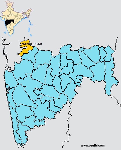
Boundaries of Nandurbar District
North and West: Gujarat
South and Southeast: Dhule District, Maharashtra
North and Northeast: Madhya Pradesh
Nandurbar District Average Rainfall: 767 mm
Nandurbar District Maximum Temperature in Summer: 38 deg C
Nandurbar District Minimum Temperature in Winter: 11 deg C
NANDURBAR DISTRICT MAP
Major Rivers: Narmada River, Tapi River, Vaki River
Taluks: Shahada, Nandurbar, Navapur, Talode, Akkalkuwa, Akrani
Assembly Constituencies: Nandurbar, Akkalkuwa, Navapur, Shahada
Nandurbar District Nearby Attractions
1. Toranmal
2. Yashwant Lake
3. Unapdev
4. Asthamba
5. Prakasha in Shahada Tehsil
6. God Shree Ganesha Temple at Jayanagar
7. Shri Datta Temple at Sarangkheda
8. Astamba Yatra in Akrani
9. Dandapaneshwar Ganesh Mandir
Nandurbar District Facts: It is one of the 12 most backward districts in Maharashtra receiving funds from the Backward Regions Grant Fund Program. A person from this district was the first one to get the 12 digit Unique Identification number of Indian Government on 29th September 2010.
Major Agricultural Products: Jawar, wheat, rice, toor, groundnuts, chilly, sugarcane, cotton, mango, banana
What is Nandurbar District Famous For: World’s largest wind farm with an output of 1000 MW
People: Tribal people namely Bhil, Pardhi, Gomit, Gavit, Pavare, Mavchi, Dhanka, Kaikadi, Dhelari
Last Updated : Friday Jun 15 , 2012