Area: 5408 square kilometers
Density of population: 185 people per square kilometer
Literacy Rate: 76.52 % - Male: 85.17 %, Female: 67.04 %
Male Female Ratio: 1000:912
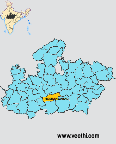
Boundaries of Hoshangabad District
North: Raisen District, Madhya Pradesh
South: Betul District, Madhya Pradesh
East: Narsinghpur District, Madhya Pradesh
South East: Chhindwara District, Madhya Pradesh
North West: Sehore District, Madhya Pradesh
West: Harda District, Madhya Pradesh
Hoshangabad District Average Rainfall: 1343.6 mm
Hoshangabad District Average Temperature in Summer: 32 deg C
Hoshangabad District Average Temperature in Winter: 19.42 deg C
HOSHANGABAD DISTRICT MAP
Major Rivers: Narmada, Tawa, Dudhi, Denwa, Morand, Banjal, Ajnal, Ganjal, Keolari, Hather, Indra Nadi
Tehsils: Seoni Malwa, Itarsi, Hoshangabad, Babai, Shohagpur, Pipariya, Bankhedi
Assembly Constituencies: Hoshangabad, Pipariya, Seoni-Malwa, Sohagpur
Hills: Satpura Range
Hoshangabad District Nearby Attractions
1. Panchmarhi Hill Station
2. Panchmarhi Sanctuary
3. Sethani Ghat
4. Ancient Petroglyphs
5. Ramji Bhabha Samadhi
6. Salkanpur
7. Hushang Shah Fort
8. Bee Fall
9. Pandav Caves
10. Dhupgarh
11. Apsara Falls
12. Duchess Falls
13. Pansy Pool
14. Waters Meet
Hoshangabad District Facts: Dhupgarh, the highest point of Satpura Range and Madhya Pradesh is located here.
Major Agricultural Products: Wheat, paddy, jowar, maize, gram, tuar, urad, pulses, soybean, ground nut, til, sugarcane, cotton, spices, vegetables
Major Industrial Products: Silk, leather, handicraft, paper, ceramics
What is Hoshangabad District Famous For: Beautiful Sethani Ghat
Hoshangabad District Pin Codes
Last Updated : Friday Jun 15 , 2012


