Date of Formation: Chatra District was carved out of Hazaribagh District in 1991.
Area: 3791 square kilometers
Density of Population: 275 people per square kilometer
Literacy Rate: 62.14 % - Male: 71.85 %, Female: 51.91 %
Male Female Ratio: 1000:951
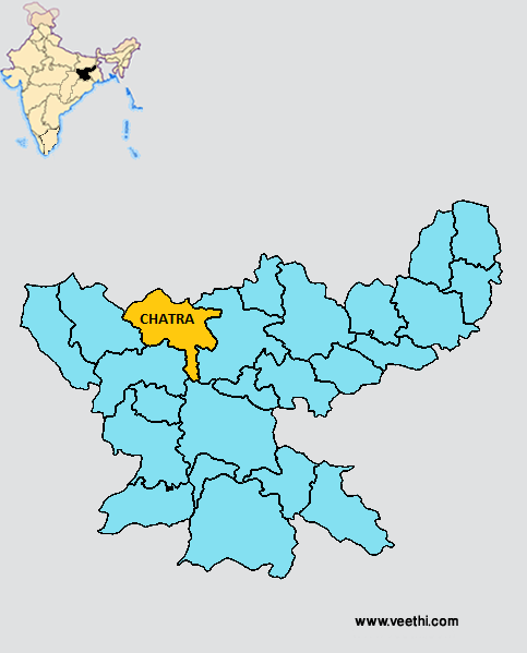
Boundaries of Chatra District
North: Bihar
South: Latehar District and Ranchi District, Jharkhand
East: Hazaribagh District, Jharkhand
West: Palamu District, Jharkhand
Chatra District Average Rainfall: 912.5 mm
Chatra District Average Temperature in Summer: 31.44 deg C
Chatra District Average Temperature in Winter: 15.78 deg C
CHATRA DISTRICT MAP
Major Rivers: River Lilajan, River Mohana
Blocks: Chatra, Gidhaur, Hunterganj, Itkhori, Kunda, Lowalang, Pathalgara, Partappur, Simaria, Tandwa
Assembly Constituencies: Chatra, Simaria
Chatra District Nearby Attractions
1. Bhaduli
2. Kolhua Hill
3. Kauleshwari Devi
4. Kunda Cave
5. Tama Sin
6. Bichkiliya
7. Duari
8. Khaya Banaroo
9. Keridah
10. Maloodah
11. Dumer Sumer
12. Barura Sharif
Chatra District Facts: This is one of the 21 most backward districts of Jharkhand that is receiving funds from the Backward Regions Grant Fund Program.
Major Agricultural Products: Bajra, maize, pulses
Major Educational Institutions: Chatra College, Hunterganj College, Nazareth Vidya Niketan High School, Rose Bird School, Anil Vidya Niketan, DAV School
Fauna: Tigers, leopards, bear, neelgai, sambhar, peacock, wild boar, deer
What is Chatra District Famous For: Its waterfalls
Last Updated : Monday Jun 11 , 2012


