Date of Formation: Rajouri District was formed out of Poonch District on 22nd September 1967 and it was officially inaugurated on 1st January 1968.
Area: 2630 square kilometers
Density of Population: 235 people per square kilometer
Literacy Rate: 68.54 % - Male: 78.38 %, Female: 57.20 %
Male Female Ratio: 1000:863
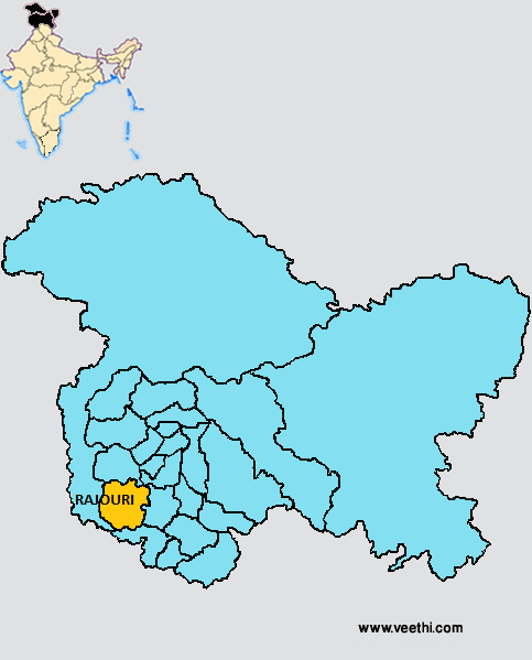
Boundaries of Rajouri District
North: Poonch District and Kulgam District, Jammu and Kashmir
South: Jammu District, Jammu and Kashmir
East: Kashmir Region
West: Reasi District, Jammu and Kashmir
Rajouri District Average Rainfall: 790.1 mm
Rajouri District Average Temperature in Summer: 33.00 deg C
Rajouri District Average Temperature in Winter: 12.62 deg C
RAJOURI DISTRICT MAP
Tehsils: Rajouri, Darhal, Kakora, Nowshehra, Thannamandi, Kalakot
Blocks: Budhal, Darhal, Kalakot, Mangota, Nowshehra, Rajouri, Sunderbani, Thanamandi
Assembly Constituencies: Nowshera, Darhal, Rajouri, Kalakot
Lakes: Akal Darshini Lake, Gum Sar Lake, Samot Sar Lake, Padyaran Sar Lake, Katori Sar Lake, Sukh Sar Lake, Chandan Sar Lake, Nandan Sar Lake, Diya Sar Lake
Rajouri District Nearby Attractions
1. Naogazi Ziarat
2. Chandan Sar
3. Divya Sar
4. Ziarat Shahdara Shreif
5. Sukh Sar
6. Gum Sar
7. Mangla Mata Temple
8. Chingas
9. Samot Sar
10. Thanamandi
11. War Memorial
12. Hall of Frame
13. Dhandidhar Fort
14. Usman Memorial
15. Balidan Bhawan
Rajouri District Facts: Rajouri is known as the Vale of Lakes.
Major Agricultural Products: Maize, rice, wheat, oil seeds
Major Occupations: Basket making, Tilla work or copper work, blanket making, Namda and Gabba making, Chikri wood carving, embroidery
Major Educational Institutions: Government Post Graduate College, Baba Ghulam Shah Badshah University
Languages Spoken: Gujri, Pahari, Dogri
Mineral Resources: Coal, limestone, bauxite, iron ore, bentonite, murree
What is Rajouri District Famous For: Lakes
Famous People From Rajouri District: Peter Qasim
Last Updated : Thursday Jun 14 , 2012


