Date of Formation: Budgam District was carved out of Srinagar District in 1979.
Area: 1,371 square kilometers
Density of Population: 537 people per square kilometer
Literacy Rate: 57.98 % - Male: 68.18 %, Female: 46.60 %
Male Female Ratio: 1000:883
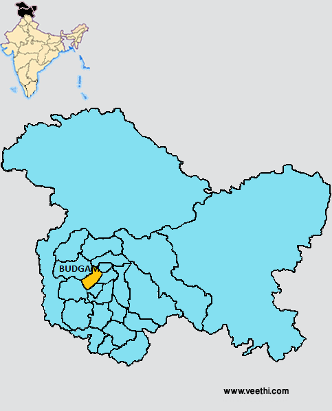
Boundaries of Budgam District
North and North West: Baramulla District, Jammu and Kashmir
North East: Ganderbal District and Srinagar District, Jammu and Kashmir
South West: Poonch District, Jammu and Kashmir
South: Shopian District, Jammu and Kashmir
East: Pulwama District, Jammu and Kashmir
Budgam District Average Rainfall: 861.0 mm
Budgam District Average Temperature in Summer: 26.78 deg C
Budgam District Average Temperature in Winter: 7.67 deg C
BUDGAM DISTRICT MAP
Major Rivers: Nilnag Lake, Tosamaidan Lake
Taluks: Beerwah, Budgam, Chadura, Khan Sahib
Blocks: Bagati Kani Pora, Beerwah, Budgam, Chadura, Khag, Khan Sahib, Nagam, Nar Bal
Assembly Constituencies: Chadura, Budgam, Beerwah, Khan Sahib, Charari Sharief
Lakes: Nilnag Lake, Tosamaidan Lake
Budgam District Nearby Attractions
1. Yousmarg
2. Toushmaidan
3. Khag
4. Sitaharan
5. World’s Biggest Chinar Chattergam
6. Nil Nag
7. Dodhpather
8. Mount Tutakuti
9. Sang E Safed
10. Tosaimaidan
11. Tomb of Sheikh Noor Ud Din
12. Imambara
13. Tom of Mir Shamas U Din Iraqi
14. Ziarat Alamdar E Kashmir
15. Tomb of Sham Ded
Budgam District Facts: There is a railway station here named Rajwansher station.
Major Agricultural Products: Maize, rice, wheat, oil seeds
What is Budgam District Famous For: Kanishawl, the variety of Kashmiri shawl
Famous People From Budgam District: Syed Ghulam Nabi Fai
Last Updated : Thursday Jun 14 , 2012


