Date of Formation: 22nd December 1972
Area: 4778 square kilometers
Density of Population: 341 people per square kilometer
Literacy Rate: 76.70 % - Male: 87.40 %, Female: 64.80 %
Male Female Ratio: 1000:884
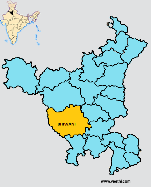
Boundaries of Bhiwani District
North: Hisar District, Haryana
South: Mahendragarh District, Haryana and Jhunjunu District, Rajasthan
East: Rohtak District, Haryana
West: Jhunjunu District and Churu District, Rajasthan
Bhiwani District Average Rainfall: 434.0 mm
Bhiwani District Average Temperature in Summer: 33.47 deg C
Bhiwani District Average Temperature in Winter: 14.28 deg C
BHIWANI DISTRICT MAP
Sub Division: Bhiwani, Dadri, Loharu, Siwani, Tosham
Tehsils: Bhiwani, Dadri, Loharu, Siwani, Bawani Khera, Tosham
Blocks: Badhra, Bawani Khera, Behal, Bhiwani, Dadri-I, Dadri-II, Kairu, Loharu, Siwani, Tosham
Assembly Constituencies: Loharu, Badhra, Dadri, Bhiwani, Tosham, Bawani Khera
Bhiwani District Nearby Attractions
1. Star Building
2. Loharu
3. Charkhi Dadri
4. Tosham
5. Maa Durga Temple in Devsar Dhaam
6. Baba Jyotram Temple
7. Shiv Temple
Bhiwani District Facts: This is the third most populous district of Haryana next only to Faridabad and Hisar
Major Agricultural Products: Bajra, wheat, cotton, sarson
Major Educational Institutions: B.R.C.M. College of Engineering, Institute of Technology and Sciences, Technological Institute of Textile Sciences, Bhiwani Institute of Technology and Science, Murari Lal Rasiwasia Ayurvedic College, Vaish College, B.L. Jindal Sui Wala College, Apeejay Saraswati College for Girls, Adarsh Mahila Mahavidyalaya
Major Industries: Textiles, guar gum, plastic granules, stone crushing, oil and oil cake, wooden and steel furniture, agricultural implements, wire drawing, fabrics and yarn
What is Bhiwani District Famous For: Its number of temples
Famous People From Bhiwani District: Noor Bano, Bansi Lal, Richhpal Ram
Last Updated : Saturday Jun 9 , 2012