Area: 4003 square kilometers
Density of Population: 857 people per square kilometer
Literacy Rate: 61.16 % - Male: 72.23 %, Female: 49.13 %
Male Female Ratio: 1000:922
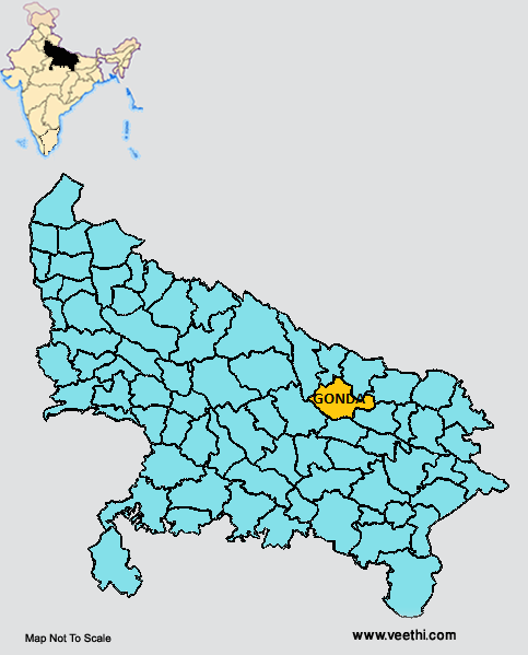
Boundaries of Gonda District
North: Bahraich District, Shravasti District and Balrampur District, Uttar Pradesh
South: Faizabad District, Uttar Pradesh
South East: Basti District, Uttar Pradesh
South West: Barabanki District, Uttar Pradesh
Gonda District Average Rainfall: 1152 mm
Gonda District Average Temperature in Summer: 33.35 deg C
Gonda District Average Temperature in Winter: 15.93 deg C
GONDA DISTRICT MAP
Major Rivers: Ghaghara, Kuon, Kuwana, Bisuhi, Manwar, Chandai, Terhi, Saryu
Tehsils: Gonda, Colonelganj, Tarabganj, Mankapur
Blocks: Babhanjot, Belsar, Chapia, Colonelganj, Haldhar Mau, Itia Thok, Jhanjhri, Katra Bazar, Mankapur, Mujehana, Nawabganj, Pandri Kripal, Paraspur, Rupaideeh, Tarabganj, Wazir Ganj
Assembly Constituencies: Mehnawan, Gonda, Katra Bazar, Colonelganj, Tarabganj, Mankapur, Gauriya
Lakes: Banki, Kodar, Aranga, Parwati, Pathri
Gonda District Nearby Attractions
1. Swami Narain Chhapia
2. Varahi Dev
3. Paska
4. Prithvi Nathan Mahadeo
5. Prash
6. Tirrey Manorama
7. Jhali Dham
8. Colonelganj Sakraura
9. Parvati Mahadeo
Gonda District Facts: This is a part of Devipatan Division.
Major Agricultural Products: Wheat, maize, paddy, gram, potato, mustard, pea, lentil, arhar, sugarcane, barley, mango, guava
Major Industries: Chini Mills, Indian Telephone Industries, pot making
Major Educational Institute: Kisan Degree College, Jagdamba Sharan Singh Educational Institute, Government Polytechnic College, Acharya Narendra Dev College of Pharmacy, Nandini Nagar Mahavidyalaya College of Pharmacy
What is Gonda District Famous For: Pottery and Chini mills
Famous People From Gonda District: Kirti Vardhan Singh, Brij Bhushan Sharan Singh, Upendra Singh, Vijay Yadav
Last Updated : Tuesday Jun 12 , 2012