Date of Formation: Bagpat District was carved out of Meerut District in 1997.
Area: 1321 square kilometers
Density of Population: 986 people per square kilometer
Literacy Rate: 73.54 % - Male: 84.17 %, Female: 61.22 %
Male Female Ratio: 1000:858
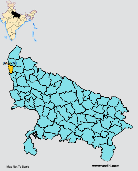
Boundaries of Bagpat District
North: Prabuddh Nagar District, Uttar Pradesh
South: Ghaziabad District, Uttar Pradesh
East: Meerut District, Uttar Pradesh
West: Haryana
Bagpat District Average Rainfall: 630.1 mm
Bagpat District Average Temperature in Summer: 32.93 deg C
Bagpat District Average Temperature in Winter: 14.12 deg C
BAGPAT DISTRICT MAP
Major Rivers: River Yamuna
Tehsils: Baghpat, Baraut, Khekra
Blocks: Bagpat, Baraut, Binauli, Chhaprauli, Khekra, Pilana
Assembly Constituencies: Chhaprauli, Baraut, Baghpat
Bagpat District Nearby Attractions
1. Yamuna Ghat
2. GufaWala Mandir
3. Pura Mahadev
4. Bhole Ki Jhaal
5. Barnawa Ka Sanskrit Gurukul
6. Saccha Sauda
7. Valmiki Ashram
8. Lakshagrah
9. Chandraprabhu Digamber Jain Atishya Kshetra
Bagpat District Facts: This district is noted for the criminal activities and the groups of criminals are known as Giroh. This is a part of Meerut Division.
Major Agricultural Products: Sugarcane, wheat, mustard, vegetables
Major Industries: Sugar mill
Major Educational Institutions: Chaudhary Charan Singh College, Shri Asha Ram Digambar Jain Girls College, Sri Sanskrit Mahavidyalaya, Mahamana Malviya Degree College, D A V Public School, Vidya Sagar School, Johar Public School, Millennium Public School
What is Bagpat District Famous For: Its green and clean environment, Digambar Jain College and Jat College
Famous People From Bagpat District: Pravesh Rana, Rajendra Singh
Last Updated : Tuesday Jun 12 , 2012


.jpeg "Rani Lakshmibai")

