Date of Formation: Kupwara District was carved out of Baramulla District in 1979.
Area: 2379 square kilometers
Density of Population: 368 people per square kilometer
Literacy Rate: 66.92 % - Male: 77.10 %, Female: 54.79 %
Male Female Ratio: 1000:843
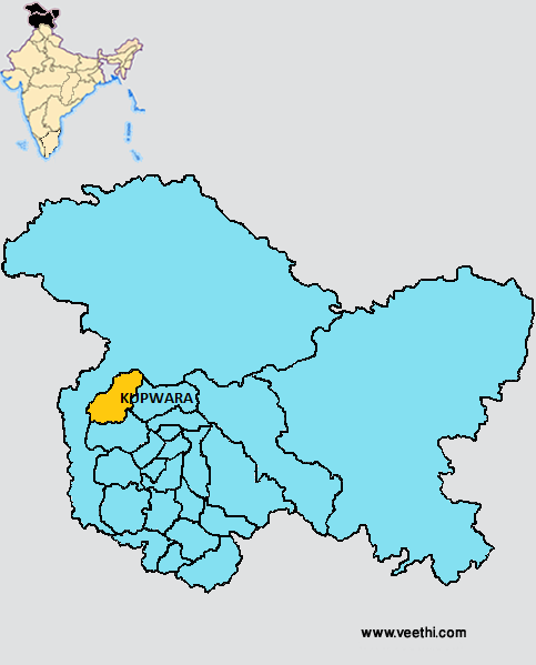
Boundaries of Kupwara District
North and West: Kashmir Region
South: Baramulla District, Jammu and Kashmir
East: Bandipora District, Jammu and Kashmir
Kupwara District Average Rainfall: 480.3 mm
Kupwara District Average Temperature in Summer: 15.60 deg C
Kupwara District Average Temperature in Winter: 1.71 deg C
KUPWARA DISTRICT MAP
Major Rivers and Canals: Bapora Khul, Bata Moji, Chota Khul, Dall Khul, Dahgam Khul, Dahgam Khul, Dudi, Hee Bar, Kahmil, Kishan Ganga, Kalaroos Nala, Kashur Nala, Lal Khul, Mawer, Manchir, Puhru, Nala Vij, Rehman Dulij, Taler
Tehsils: Handwara, Karnah, Kupwara
Blocks: Kalarooch, Kral Pora, Kupwara, Langet, Rajwar, Ramhal, Sogam, Tangdhar, Tumina, Trehgam, Voora
Assembly Constituencies: Karnah, Kupwara, Lal Pora, Handwara, Langet
Kupwara District Nearby Attractions
1. Karnah Micro Hydel Project
2. Nandrishi Pir’s Tomb
3. Dhyaneshwar Temple at Smattan
4. Ruins of Ramkund Temple
5. Shardania Temple at Guglusa
6. Jamia Masjid
7. Gazi Masjid
8. Kheer Bhawani Temple
9. Badra Kali Temple
Kupwara District Facts: This is one of the three most backward districts of Jammu and Kashmir that is receiving funds from the Backward Regions Grant Fund Program.
What is Kupwara District Famous For: Number of Shrines
Famous People From Kupwara District: Maqbool Bhat, Abdul Ghani Lone
Last Updated : Thursday Jun 14 , 2012


