Date of Formation: 15th August 1995
Area: 898 square kilometers
Density of Population: 622 people per square kilometer
Literacy Rate: 83.40 % - Male: 88.60 %, Female: 77.50 %
Male Female Ratio: 1000:870
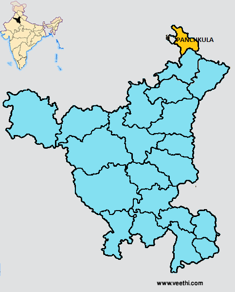
Boundaries of Panchkula District
North: Himachal Pradesh
South: Chandigarh
East: Ambala District, Haryana
West: Punjab
Panchkula District Average Rainfall: 608.6 mm
Panchkula District Average Temperature in Summer: 33.32 deg C
Panchkula District Average Temperature in Winter: 13.79 deg C
PANCHKULA DISTRICT MAP
Major Rivers: Ghaggar, Sirsa Nadi, Kaushalya
Blocks: Barwala, Mauli, Pinjore, Raipur Rani
Assembly Constituencies: Kalka, Panchkula
Panchkula District Nearby Attractions
1. Mansa Devi Temple
2. Pinjore Gardens
3. Morni Hills
4. Kalka
5. Urban Estate
Panchkula District Facts: This is the least populous district of Haryana.
Major Agricultural Products: Wheat, gram, barley, barseem, methi, onion, sugarcane, paddy, maize, chili
Major Educational Institutions: Brahamrishi College of Education, BRS Dental College, SDD Institute of Management Studies, Swami Devi Dyal Hospital and Dental College, Swami Dyal Institute of Engineering and Technology, Swami Devi Dyal College of Law, SDD Institute of Pharmacy, Swami Devi Dyal College of Education, Swami Devi Dyal College of Nusing
What is Panchkula District Famous For: Cactus Garden
Famous People From Panchkula District: Aruna Asaf Ali, Bhajan Lal Ved Prakash Malik
Last Updated : Saturday Jun 9 , 2012


