Area: 3882 square kilometers
Density of population: 763 people per square kilometer
Literacy Rate: 75.59 % - Male: 85.29 %, Female: 64.95 %
Male Female Ratio: 1000:914
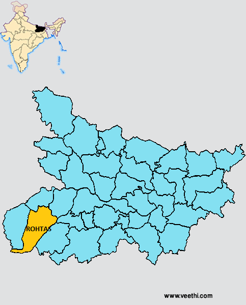
Boundaries of Rohtas District
North: Buxar District and Bhojpur District, Bihar
South West: Jharkhand
South East and East: Aurangabad District, Bihar
West: Kaimur District, Bihar
Rohtas District Average Rainfall: 782.56 mm
Rohtas District Average Temperature in Summer: 33.24 deg C
Rohtas District Average Temperature in Winter: 16.26 deg C
ROHTAS DISTRICT MAP
Major Rivers: Sone River, Kaw River
Sub Divisions: Sasaram, Bikramganj, Dehri
Blocks: Nauhatta , Chenari, Nasriganj, Rohtas, Shivsagar, Dawath, Karakat, Nokha, Vikramganj, Kargahar, Sasaram, Dihra, Dinara, Kochas, Aliganj Tola, Rajpur, Tilauthu, Suryapura, Sanjhauli
Assembly Constituencies: Chenari, Sasaram, Kargahar, Dinara, Nokha, Dehri, Karakat
Rohtas District Nearby Attractions
1. Rohtas Garh
2. Sasaram
3. Shergarh
4. Tarachandi
5. Dhurwan Kund and Gupta Dham
6. Bhaluni Dham
7. Dharklandha
8. Akbarpur
9. Akhorigola
10. Dehri
11. Deo Markandey
12. Rehal
13. Kaimur Wildlife Sanctuary
Rohtas District Facts: It is one of the 36 most backward districts in Bihar and is receiving funds from the Backward Regions Grant Fund Program.
Major Agricultural Products: Paddy, wheat
Major Industries: Cement factory, vegetable oil mill, paper factory
What is Rohtas District Famous For: Rohtas Garh Fort
Famous People From Rohtas District: Jagjivan Ram
Last Updated : Thursday Jun 14 , 2012


